


























Google DeepMind and Google Research just put WeatherNext 3 into Search, Maps, Gemini, the Maps Platform Weather API, and Earth Engine. The new model ingests live geostationary satellite mosaics and writes a fresh global forecast every hour. Google calls it the most advanced and accurate global weather model to date, according to independent live evaluations by Brightband.
Hourly refreshes, five times sharper
WeatherNext 2 sat on a 25-kilometer grid and updated every six hours. WeatherNext 3 instead maps temperature and moisture at 5 kilometers, other surface variables at 10 kilometers, and atmospheric fields such as wind at 25 kilometers. Google says that picture is roughly five times sharper. Specifically, it can follow local topography instead of smearing a coastline into one fat pixel.
The bigger change is the data diet. Most AI weather models, including WeatherNext 2, train on numerical weather prediction output. Those physics simulations carry about a six-hour lag. Meanwhile WeatherNext 3 pulls a live, global satellite mosaic plus sparse weather-station observations. Then it can refresh every hour at up to 5-kilometer resolution.
Rain and snow were the weak spot
Precipitation is the hard part. Fast cloud processes sit below the scale of traditional global models, so AI maps often blur rain bands or miss storm edges. Google trained WeatherNext 3 on NASA IMERG satellite rain retrievals and on its own satellite-radar precipitation reanalysis. It reports CRPS gains of up to 60% against IMERG, 30% against MRMS, and 10% against rain gauges at early lead times.
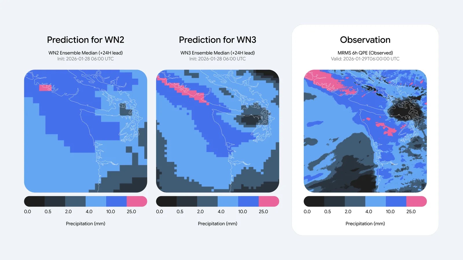
In Search, Maps, and Gemini, Google says people planning a day or more ahead will see up to 50% more accurate precipitation forecasts. The largest gains, it says, land in regions that historically got weaker high-resolution coverage, including parts of Latin America, Africa, and Asia-Pacific. Also, the model adds 100-meter wind speeds for turbines, plus cloud cover and solar radiation for farms. That sits next to other weather-aware energy tools such as Jackery’s Ark AI EMS.
In Google apps today, still not the official warning
Developers can query the hourly grids in BigQuery and Earth Engine, or bulk-download from Cloud Storage. Google also points researchers to Weather Lab and an arXiv paper. However, the company still tells people to treat national weather services as the source for warnings and public-safety calls. Still, this is another DeepMind model leaving the lab, much like TacticAI’s move onto a real football club. Besides the Brightband leaderboard Google cites, we have not independently verified the skill scores.